![]()
 These satellite locator beacons have recently become available through the consumer market. They are relatively inexpensive and operate in real time, updating the boats current location on the internet every ten to fifteen minutes. The concept we are testing in this pilot is to loan these personal satellite beacons to shark boat captains through the traditional fishing authority, the Panglima Laot.
These units have three different buttons on them, we have shown the captains how to turn the unit on and off, they are to press the second button if they need immediate help and the third button if they see illegal fishing. If possible, the captain will then take a picture (this is sometimes dangerous because boats illegally fishing will sometimes shoot at local fishers in order intimidate them and make them keep their distance).
We have found in discussions with the captains that even if he has a radio and it is near enough to shore to be heard, and someone within range happens to be listening, the fishermen will not report illegal fishing for fear that they will be overheard on the radio. In addition, the culture of Aceh after thirty years of conflict is such that one does not turn in others to the government.
The fishermen will not allow the government to monitor where they go (For example: secret fishing grounds, or fear of punishment should they go into another countrys waters). However, in the Acehnese social structure, the Panglima Laot has the responsibility to organize rescues, and so the fishing boat captains trust the Panglima Laot to monitor their locations.
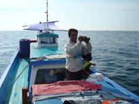
 Upon return to port, the captain will come to the Panglima Laot office, download pictures, get new batteries for satellite transmitter and report catch; sizes and species.
The benefits to the fishermen are:
The benefits to the conservationist are:
The benefits to government:
See also Satellite tracking of FADs, Thai fishing boat caught fishing just 30 miles off the West coast of Aceh